Remote Island Monitoring

NDWI
NDVI
PSinSAR
DinSAR
AI CNN
Monitoring uninhabited island
from multiple satellite data
SAR
Intensity
Costal Erosion
Illegal Logging
Illegal Sand Mining
Illegal Occupation
Illegal Dumping
Service
Overview
Our remote island monitoring service uses integrated multiple satellites data to monitor uninhabited islands and remote islands scattered across a wide aream frequently. Remote islands face a variety of problems, for example, coastal erosion, illegal deforestation, illegal dumping, illegal sand mining, illegal occupation, etc. In general, uninhabited islands scattered across a vast area are managed by regular patrols by humans, but this service integrates and uses a wide variety of large amounts of satellite data, realizing more frequent, more diverse, and less costly monitoring of uninhabited islands, addressing the various issues they face.
Expected
Benefits
-
For events such as coastal erosion, illegal deforestation, illegal dumping, illegal sand mining, and illegal occupation, automatic analysis is carried out using data from multiple satellites, such as NDWI (Natural Moisture Index), NDVI (Vegetation Index), machine learning, and changes in backscattering intensity, to detect changes (anomalies) over time.
-
Using a virtual satellite constellation, optical/SAR satellite observations are optimized based on the satellite's orbit and weather conditions for the observation target, and observation data suited to the purpose is selected.
-
Changes (anomalies) will be detected and provided by using a hexagonal grid. Based on the user's needs, such as the amount of data analysis processing, we select an appropriate grid size, improve the efficiency of data processing, and provide an automated system.
Service Flow
Preparation
Delivery
Selection of monitoring targets:
Select monitoring targets such as coastal erosion, illegal deforestation, illegal dumping, illegal sand mining, and illegal occupation.
Selection of monitoring frequency:
Decide the monitoring frequency and the optimal combination of satellite data to use
Use of multiple satellite data:
We will calibrate and harmonize the data from multiple satellites to be used, creating an environment for integrated use.
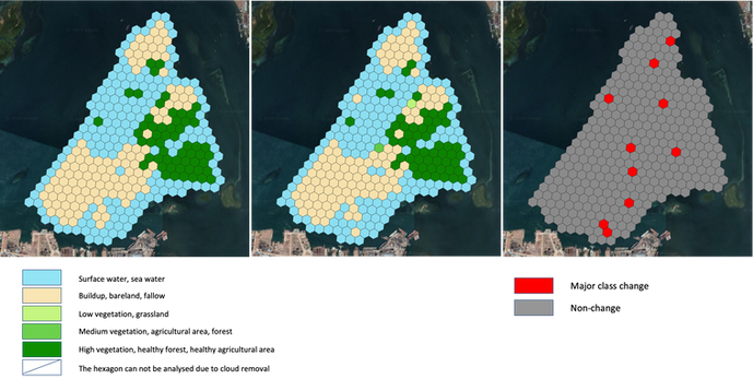
Anomaly detection service:
We will conduct satellite observations over time, detect anomalies by analyzing data from multiple satellites, and provide information on changes.
Click here to see related press release
Click here to inquire about this service.